
12 Best Hikes In New Zealand You Shouldn’t Miss
This post contains affiliate links, including Amazon affiliate links. If you purchase through these links, I may earn a commission at no extra cost to you. As an Amazon Associate, I earn from qualifying purchases. Thank you for your support!
By Sarah Ingleton. This post on New Zealand hikes features affiliates links to trusted partners.
Looking for the best hikes in New Zealand?
Then you’re in the right place!
New Zealand is blessed with many incredible hikes. From awesome day walks in Auckland to truly memorable trails like the Hooker Valley Track and Tongariro Alpine Crossing, there is something for everyone.
With short walks, day-long treks, and multi-day tramps, New Zealand has it all!
And if you need some help choosing your perfect trek, we’ve got you sorted with a detailed list of incredible trails for people of all ages and abilities — some so renowned they’re known as the “Great Walks of New Zealand”.
On that note, strap on your boots and let’s dive into 12 unforgettable New Zealand hiking trails!
What Type Of Hiker Are You? [Free Quiz]
But first…
Before we dive into our New Zealand travel guide sharing the best walks in NZ, I want to share a free personality quiz I think you’ll love:

It’s called “What type of hiker are you?” and it will help you discover your hiking personality.
Bonus:
Your results also share trail suggestions based on your results!
New Zealand Map
To help give you a lay of the land so you can better understand where each of the below New Zealand hiking trails are located, here is a map showing the country’s regions:
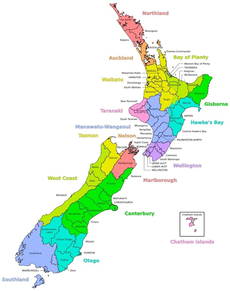
On that note, let’s dive into our list of New Zealand’s great walks, separated by location.
Best Hikes In New Zealand (By Destination)
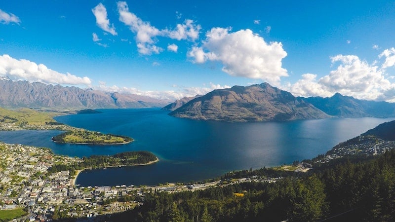
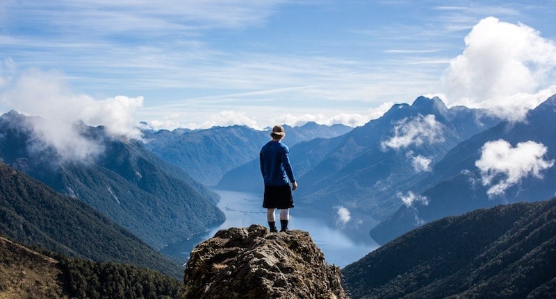
Queenstown
1. Queenstown Hill Walking Track
Trail Difficulty: Intermediate
Length: 2.5 kilometers (1.6 miles)
Location: Queenstown, New Zealand — known as “the adventure capital of the world”. This popular resort town also has plenty of restaurants, accommodation to suit all budget ranges, and shops to enjoy, as well as numerous outdoor activities.
Trailhead: The track entrance is located in a small car park off Belfast Terrace Road, only a few minutes away from the city center. You can simply put “Queenstown Hill Walking Track” into Google Maps to have it populate.
Trail Map: Click here for a Queenstown Hill Track map.
About This New Zealand Trail:
The Queenstown Hill Walking Track is one of the best hikes in New Zealand’s South Island; an epic day hike that takes you uphill through pine forest before branching out into two different paths.
By taking the right path, you’ll find walking a bit easier, but the time it takes to walk the track is slightly longer. The left path is shorter but is more challenging.
As you make your way around the track, you will see six information plates describing the history of Queenstown and Lake Wakatipu, as well as the “Basket of Dreams” sculpture.
The views at the summit will make the climb worth every minute. From there, you have 360-degree views of Ben Lomond Track, the Remarkables Mountain Range, and Lake Wakatipu.
A round trip of the track takes around two to two-and-a-half hours.
It’s recommended to take a hiking pole as the track does become quite steep. Investing in some of the best clothes for hiking as well as good hiking boots are a must if you go in winter as the hill can become slippery with snow.
Additionally, it’s a smart idea to take a sweater or light jacket with you as the weather changes quickly.
Warning:
Part of the track traverses private land. Please respect the landowner’s rights by sticking to the trail.
Tongariro National Park
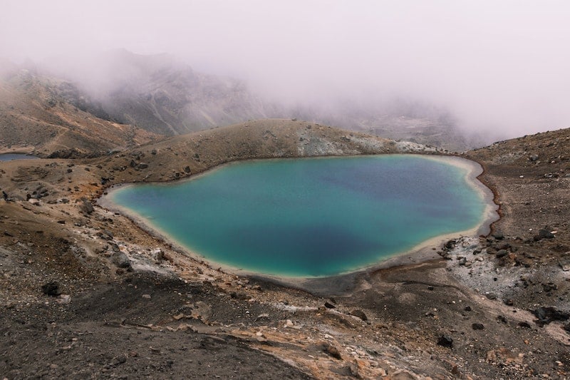
2. Tongariro Alpine Crossing
Trail difficulty: Intermediate to Hard
Length: 19.4 kilometers (about 12 miles)
Location: Tongariro National Park, North Island. Tongariro National Park is New Zealand’s first National Park and is also a UNESCO World Heritage site, full of cultural significance and natural beauty. It’s also a popular option for solo female travelers in New Zealand.
Trailhead: The trail starts at Mangatepopo Road — which is seven kilometers (about 4.5 miles) off SH47 — and ends at Ketetahi Road. The Tongariro Alpine Crossing is not a loop track and ends at a different point from where it starts.
The best thing to do is catch a shuttle from either Taupo or Turangi as there are four-hour maximum parking restrictions in place at both ends of the track.
Trail Map: Click here for a Tongariro Alpine Crossing trail map.
About This New Zealand Trail:
The track on the Tongariro Alpine Crossing is a bit flat to start off with; however, the path slowly climbs from about 1120 meters to 1886 meters, which is the highest point on the crossing.
The trip up the alpine crossing takes you over ancient and modern lava flows. Be sure to take some photos of the stunning Emerald Lakes on your way up to the Red Crater at the top!
In terms of timing, this trip takes about six-to-nine hours depending on your climbing ability and the season.
This is definitely a track for more experienced climbers, especially in winter when the weather is extreme. During this time, crampons, ice axes, and warm clothing layers are a must!
Take some sunscreen, a flashlight, and high-energy food and water with you too, as there are no stores along the track. Moreover, the water in the lakes and streams is not suitable to drink.
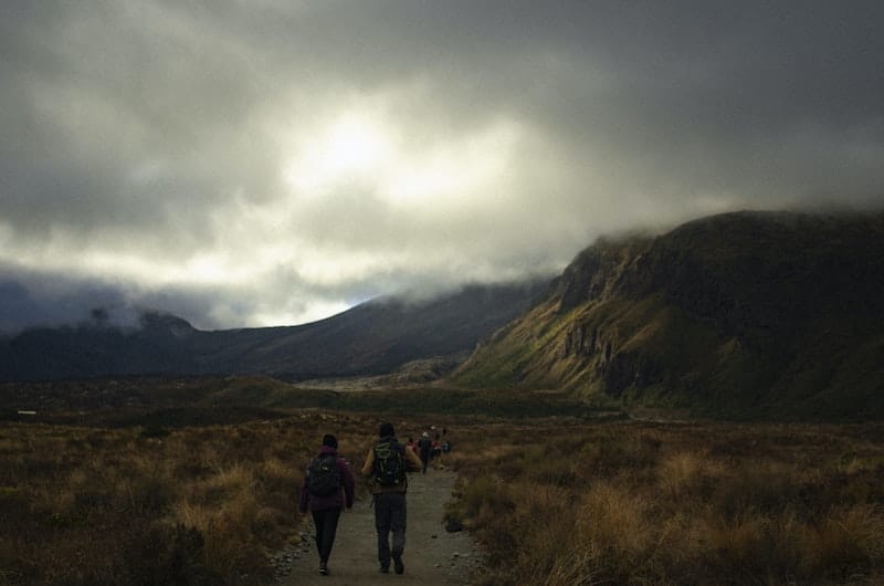
3. Tongariro Northern Circuit
Trail difficulty: Intermediate to Hard
Trail length: 43.1 kilometers (about 27 miles)
Location: Tongariro National Park, North Island.
Trailhead: The track begins about 100 meters (~a half-mile) from Whakapapa i-Site, which is the information center. Whakapapa is a small town located about 100 kilometers (~62 miles) southwest of Taupo, the largest nearby city. From here, the circuit can be walked in either a clockwise or anti-clockwise direction.
Trail Map: Click here for a Tongariro Northern Circuit trail map.
About This New Zealand Trail:
One of the “Great Walks of New Zealand”, the Tongariro Northern Circuit is a longer version of the Tongariro Alpine Crossing.
During the Alpine Crossing part, the track is more crowded but those crowds will soon thin out once you leave the main track.
In addition to the sights on the Tongariro Alpine Crossing, you will see some plant life such as the golden and red tussocks. If you come in summer, you’ll also get to see purple parahebe, mountain buttercups and daisies, white foxgloves and eyebrights, and gentian.
If you are lucky, you may also catch a glimpse of the endangered whio (blue duck), bellbirds, and kereru (wood pigeons).
If you’re looking for the best multi-day hikes in New Zealand, this trek fits the bill, taking three-to-four days to complete.
Bonus:
Lord of The Rings fans can also check out the views of Mount Ngauruhoe (aka Mt. Doom). It’s truly a bucket list walk!
Now, let’s chat for a moment about accommodation along the hike.
There are three huts that are available to stay in, including Mangatepopo, Oturere, and Waihohonu.
There are also some campsites along the track but if you’re going to use those, take a gas cooking stove with you too as the hut facilities won’t be available to you if you choose to stay at a campsite.
Book these huts well in advance of your trip to make sure you get a spot! Bookings are essential during the Great Walks season from late October through late April.
Off-season, bookings are not required and huts and campsites are available on a first-come, first-served basis.
Fun fact:
Aside from the Aotea Track, the Tongariro North Circuit is the northern-most multi-day hike in New Zealand!
4. Taranaki Falls Track
Trail Difficulty: Easy to Intermediate
Trail Length: 6 kilometers (~3.7 miles)
Location: Tongariro National Park, North Island.
Trailhead: The trail is in Whakapapa Village, 100 meters (~328 feet) downhill from the Tongariro National Park information center. There is a car park at the road end of Ngauruhoe Terrace where Upper Taranaki Falls Track begins.
Trail Map: Click here for a Taranaki Falls Trail map.
About This New Zealand Trail:
Looking for the best day hikes in New Zealand?
This walk takes only a couple of hours and is even suitable for children above the age of seven.
On this hike, you’ll see alpine shrublands, tussocks, and beech forests. If it’s a clear day, you might even see a few notable mountains including Ngauruhoe, Tongariro, and Pukekaikiore.
The forest is filled with large mountain beech trees, shiny broadleaf, and umbrella ferns, among others.
Additionally, if you enjoy wildlife and bird-watching, there’s plenty of birdlife like grey warblers and rifleman.
The ascent to Taranaki Falls is about 100 meters (~328 feet) of steps before the track joins with Tama Lakes Track. Here you turn right to return to Whakapapa.
Fiordland National Park
5. Milford Track
Trail Difficulty: Intermediate
Trail Length: 53.5 kilometers (~33 miles)
Location: Fiordland National Park, South Island.
Trailhead: To get to Milford Track, either drive four hours down Milford Road from Te Anau or catch a coach from Te Anau.
From there, take a boat trip to Glade Wharf at the head of Lake Te Anau. This trip takes around an hour and 15 minutes.
From here, you can see Mitre Peak, which appears as a single sharp point rising up 1,690 meters (5,560 feet) over Milford Sound. It’s one of the most photographed places in New Zealand and is the perfect place to upgrade your Instagram shots.
The track is one way and ends at Sandfly Point.
Trail Map: Click here for a Milford Track map.
About This New Zealand Trail:
Often touted as one of the best hikes in the world, Milford Track is the most famous hike in NZ and another of the “Great Walks of New Zealand”.
It takes about four days to complete, although the first day’s walk is a bit shorter and can be done in the afternoon.
There are three huts along the track, including Clinton Hut, Mintaro Hut, and Dumpling Hut.
These huts are equipped with cooking facilities and fuel during the Great Walks season; however, if you’re going during the off-season you’ll need to take your own gas cooking stove.
At Clinton Hut, the first hut along the route, there are some glow worms. At night, you might also hear the sounds of kiwis, which are flightless birds endemic to New Zealand. How cool is that?
The treks between each hut take around six-to-seven hours each.
In terms of what you’ll see, this New Zealand hiking trail takes you through mossy forests and alpine scenery. There’s plenty of waterfalls too — especially after it rains — which really adds to the beauty of the place!
On that note, it’s a good idea to take a raincoat with you too as it rains frequently in Milford Sound.
Again, this is a very popular walk and one of the best hikes in New Zealand on the South Island, so it’s essential to book huts well in advance of travel. Camping on Milford Track is not permitted.

6. Kepler Track
Trail difficulty: Intermediate to Difficult
Trail length: 60 kilometers (~37 miles)
Location: Fiordland National Park, South Island.
Trailhead: The Kepler Track starts at the Control Gates near the shore of Lake Te Anau. The trail is a circular loop that can be walked in either direction.
Trail Map: Click here for a Kepler Track map.
About This New Zealand Trail:
You’ll see everything from waterfalls to glacial valleys on the Kepler Track. There are even some caves to explore!
This New Zealand hiking trail is another of the Great Walks and takes around four days to complete. Be warned, there are some steep climbs here, especially on Day 2!
In terms of amenities, there are three huts along the trail, including Luxmoore Hut, Iris Burn Hut, and Moturau Hut. The walk between these takes five-to-six hours each.
The huts have bunks, heating, toilets, cold running water, and basic cooking facilities; however, there are no showers and you’ll need to bring your own cooking utensils.
You’ll also want to boil any water before you use it.
While you can camp at Iris Burn Hut, camping at Forest Burn or Hanging Valley is not permitted. Make sure you book ahead!
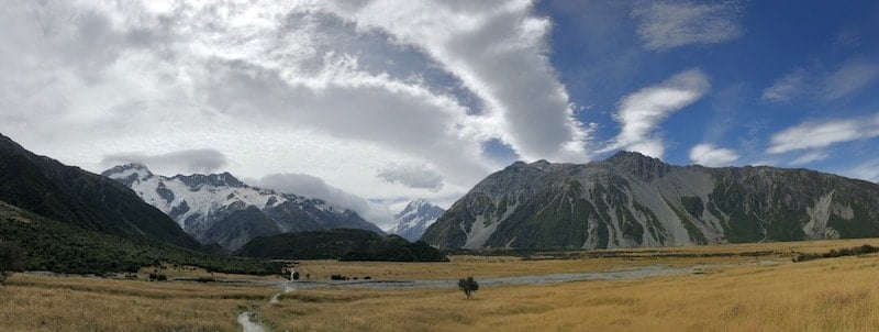
Aoraki/Mount Cook National Park
There are several walks available at Mt Cook, though here we’ve provided three of the best hikes in Aoraki/Mt Cook National Park.
This alpine park was established in 1953 and has a whopping 19 peaks, each around 3,000 feet high. The countryside is certainly dramatic, with five major valley systems and more than 100 smaller hanging glaciers.
Bonus:
From Mt Cook National Park you’re only a five-hour drive from another fantastic New Zealand hike: the Copland Track to Welcome Flat Hut!
7. Kea Point Track
Trail Difficulty: Easy
Trail Length: 3.2km (2 miles)
Location: Aoraki/Mt Cook National Park, Canterbury, South Island.
Trailhead: For the short version of this walk, begin at the White Horse Hill campground at the end of Hooker Valley Road. For the longer version of this walk, begin at Whakapapa Village.
Trail Map: Click here for a map of Kea Point Track
About This New Zealand Trail:
This is a nice, easy two-hour walk from the main village — or a one-hour return from the White Horse Hill Campground and carpark.
It offers fantastic views of Mount Footstool, Mount Sefton, Hooker Valley, and of course, Aoraki/Mount Cook.
8. Sealy Tarns Track
Trail Difficulty: Medium
Trail Length: 5.8 kilometers (3.6 miles) round trip
Location: Near Mount Cook Village, Aoraki/Mt Cook National Park, Canterbury, South Island.
Trailhead: The Sealy Tarns Track branches off the Kea Point Track, so it can also be accessed from Mount Cook Village or White Horse Hill campground.
Trail Map: Click here for a Sealy Tarns Track map
About This New Zealand Trail:
This walk is also known as the “Stairway to Heaven” as you’ll climb 2,200 steps!
This New Zealand hike takes about three hours and is fairly steep, but it’s all worth it when you see the views of the Hooker Valley and Mount Cook, as well as the alpine flowers.
You might even see some keas — the world’s only alpine parrot!
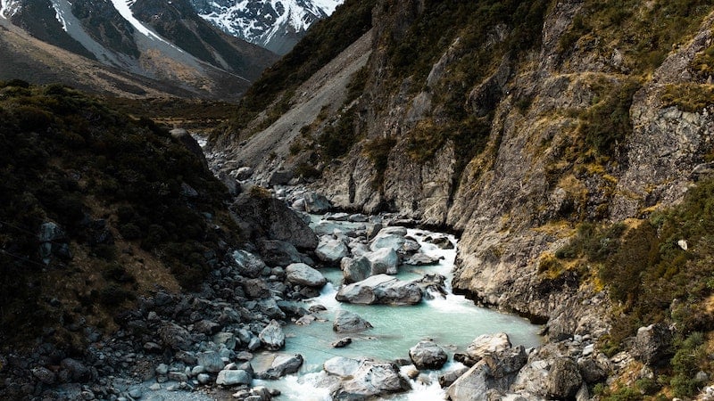
9. Hooker Valley Track
Trail Difficulty: Easy
Length: 10 kilometers (~6.2 miles)
Location: Aoraki/Mount Cook National Park, Canterbury, South Island.
Trailhead: The Hooker Valley Track starts at White Horse Hill campground in the park.
Trail Map: Click here for a Hooker Valley Track map.
The Hooker Valley Track is truly one of the best hikes in NZ thanks to gorgeous scenery and a diverse trail showcasing three swingbridges to cross.
This New Zealand hiking trail also showcases the world’s largest buttercups! These are called Mount Cook Buttercups and their leaves reach up to 40 centimeters (almost 16 inches) across.
The best time to walk this trail is early in the morning, as this allows you to avoid the crowds.
Plus, it’s the best time of day to take those all-important photos as souvenirs of your trip. Here is a guide on how to take better travel photos if you need some tips, too!
Mount Aspiring National Park: Home To Some Of The Best Hikes In New Zealand
10. Gillespie Pass
Trail Difficulty: Difficult
Length: 58 kilometers (~36 miles)
Location: Mount Aspiring National Park, Otago, South Island.
Trailhead: A few kilometers north of Makaora, a small town near Lake Wanaka, is a car park with a sign that marks the entrance to the track.
Trail Map: Click here for a Gillespie Pass trail map.
About This New Zealand Trail:
If you’re after a challenging walk, here it is! The Gillespie Track Pass takes three-to-four days to complete. Each day offers plenty of walking, with several hours between each hut.
If you allow an extra day or so of walking, it’s recommended to take a side trip to Lake Crucible — which is out-of-this-world gorgeous thanks to its blue and green hues.
Pro tip:
While this is a less-trafficked trail you should book Siberia Hut — an overnight accommodation home to a small waterfall and incredible star-gazing opportunities — in advance as there are usually a large number of people staying there.
One reason there are fewer people actually on the trail is that it’s very physically demanding and only for the most experienced hikers out there.
Additionally, there are a number of river crossings that may flood and become impassable, so this hike should only be attempted during summer. River crossing experience is essential.
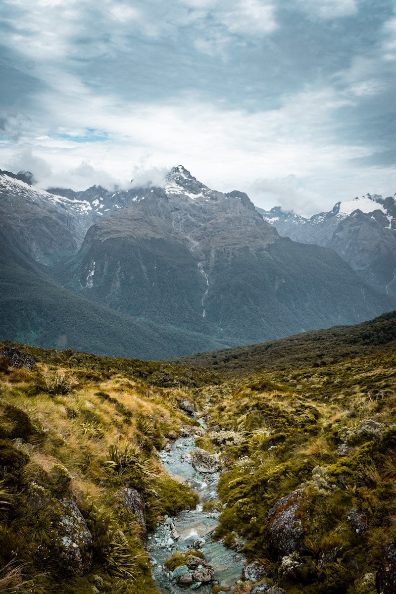
11. Routeburn Track
Trail difficulty: Easy – Intermediate
Trail length: 32 kilometers (~20 miles)
Location: Mount Aspiring and Fiordland National Parks, South Island, New Zealand.
Trailhead: Routeburn Track can be accessed either from the town of Te Anau or the settlement of Glenorchy, which is at the northern end of Lake Wakatipu. Public transport is available from both ends of the track.
Trail Map: Click here for a Routeburn Track map.
About This New Zealand Trail:
This is one of the most famous treks in New Zealand and connects the Dart Valley Track in Mount Aspiring National Park with the Hollyford Valley Track in Fiordland National Park.
It takes about two-to-three days to complete and has three huts along the trail that are available to stay in, including Routeburn Falls Hut, Mackenzie Hut, and Howden Hut,
The landscape is straight out of Lord of The Rings, with diverse scenery such as beech forests, waterfalls, mountain vistas, and alpine lakes.
In fact, it has some of the best scenery all in one location so it’s definitely the walk to take if you only have a limited time in South Island or New Zealand.
Taranaki/Egmont National Park
12. Around The Mountain Circuit
Trail Difficulty: Hard
Trail Length: 52 kilometers (~32 miles)
Location: Mount Egmont National Park, Taranaki, North Island.
Trailhead: Begin and finish at the Taranaki/Egmont Park visitor center at North Egmont.
Trail Map: Click here for an Around The Mountain Circuit trail map.
About This New Zealand Trail:
If you’re looking for the best hikes in New Zealnd on the North Island, this is a great option.
The Around The Mountain Circuit is a challenging walk with plenty of lava cliffs, goblin forests (forests full of gnarly, twisted trees) and waterfalls. Of course, there’s Mount Taranaki itself looming in the background as well.
The track takes around four to five days and there are four serviced huts along the track. Bookings are not required for these huts and visitors can stay on a first-come, first-served basis.
Important note:
This track isn’t especially well-marked so you’ll need to have good navigation skills and a well-drawn topographical map handy.
Furthermore, be careful of the stream and river crossings as most of them are unbridged and the track can get muddy at times too.
Best Hotels in New Zealand
Looking for nice hotels in New Zealand?
Click here for a list of local hotels!
Prefer self-contained stays?
Click here to check out unique local rentals!
You can also use the map below to search for local stays:
Getting Around New Zealand
The best way to explore the many New Zealand hiking trails and fun things to do is by car.
Recommendation:
Use Discover Cars to quickly compare your car rental options.
Their comparison tool does the homework for you, so there’s no need to have up 10+ tabs trying to figure out which company is the most affordable. Actually, you can save up to 70% using their tool!![]()
Top New Zealand Tours
After you’ve checked out New Zealand’s best hikes, explore the destination through a local tour, like:
- Hobbiton Movie Set and Waitomo Glowworm Caves Day Trip from Auckland
- Franz Josef Heli Hiking Guided Tour
- Arthur’s Pass Full-Day Tour Includes TranzAlpine Express Train from Christchurch
- Piha and Karekare Rainforest Wine Tour from Auckland
Click here for a full list of New Zealand tours.
New Zealand Travel Insurance
When visiting New Zealand — or anywhere else in the world — make sure to get travel insurance.
One of the best travel medical insurance for travelers is SafetyWing as they’ve got a large network and offer both short-term and long-term coverage — including coverage if you’re traveling for months as well as limited coverage in your home country).
Additionally, SafetyWing is budget-friendly and offers $250,000 worth of coverage with just one low overall deductible of $250.
Click my referral link here to price out travel insurance for your trip in just a few clicks.
What trails would you add to this list of the best hikes in New Zealand?

Enjoyed this amazing hiking trails in New Zealand? Pin the post for later!