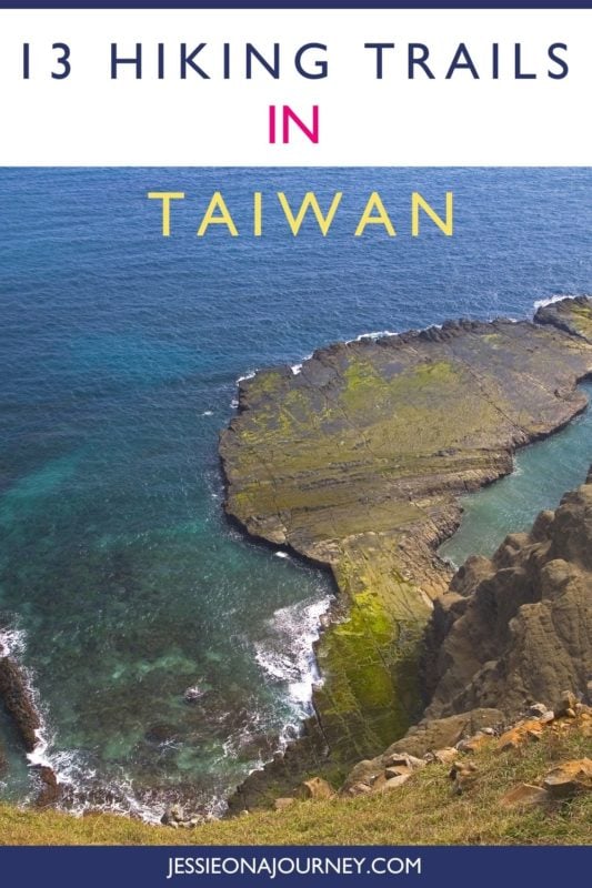
13 Best Hiking Trails in Taiwan You Shouldn’t Miss
This post contains affiliate links, including Amazon affiliate links. If you purchase through these links, I may earn a commission at no extra cost to you. As an Amazon Associate, I earn from qualifying purchases. Thank you for your support!
Looking for the best hiking trails in Taiwan?
Then you’re in the right place!
Taiwan is a frequently overlooked paradise for hikers.
This small island nation is home to the largest density of high mountains in the world, with nearly 300 peaks soaring above 3,000 meters (9,843 feet). This includes mighty Yushan, the tallest mountain in Northeast Asia.
Basically, if you’re looking for incredible Taiwan mountain hiking, you won’t be disappointed — especially since this translates to an abundant and diverse range of trails.
Want to hike through subtropical jungles then summit a snowy peak in the same day? Taiwan has you covered. Gaze at steaming volcanic fumaroles? Check. See Taiwanese macaques in the wild on an easy hike with kids? Also check.
In this post, I’ve narrowed it down to 13 of the best hikes in Taiwan, spanning the country and all hiking levels.
We’ll begin in the capital, Taipei City, before traversing the vast Central Mountain Range and finishing in Southern Taiwan.
Let’s dive into where to hike in Taiwan!
🥾 Pro tip: Before going hiking in Taiwan, make sure to download the AllTrails app to have trail guides, maps, photos, and reviews right at your fingertips. You can also sign up for a free trial of AllTrails+ to download offline maps, get alerts for wrong turns, find trails by distance from you, and more!
💪 Safety: Additionally, whether you’re hiking solo or in a group, it’s smart to keep safety in mind. One piece of advice is to carry a She’s Birdie Personal Safety Alarm, which features a 130db alarm and flashing strobe light designed to deter an attack. I also love the Garmin inReach Mini, a compact satellite communicator with SOS capabilities that can truly save your life in an emergency.
What Type Of Hiker Are You? [Free Quiz]
But first, before we get into our hiking Taiwan guide, I want to share a free personality quiz I think you’ll love:

It’s called “What type of hiker are you?” and it will help you discover your hiking personality.
Bonus:
Your results also share trail suggestions based on your results!
On that note, let’s dive into our Taiwan travel guide sharing the country’s best treks.
Map Of Taiwan
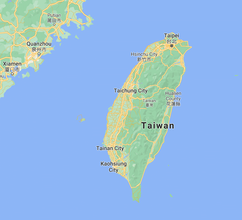
Having a map and understanding where you are and where you’re going is smart when trekking in Taiwan.
The above map offers a good starting point for getting a lay of the land.
Additionally, you can click here for an interactive Taiwan map that allows you to plug in your destination and even the trails you’ll be hiking.
Tips For Hiking In Taiwan
Whether you are already living in Taiwan or planning a hiking-focused visit, there are some important considerations you’ll want to make. Here are some tips and suggestions for hiking in Taiwan.
Best Time to Go Hiking In Taiwan
Wondering when is the best time to hike in Taiwan?
Generally speaking, the best time to visit Taiwan and go hiking there is spring and fall. The spring hiking season is around March to May, while the fall hiking season is from October to December.
Winter is Taiwan can be too chilly for comfort — unless you specifically want to go hiking in the snow, which I’ll get to below!
Meanwhile, summer is simply too hot, not to mention that it is the peak of typhoon season in Taiwan, with about half a dozen typhoons usually striking the island nation from July to September. It’s less common, but typhoons can come as late as October or even November.
Here is more information about the best times to visit Taiwan, including a month-by-month comparison.
Taiwan Hiking Safety
One of the most important safety concerns when hiking in Taiwan is the very real possibility of landslides after typhoons or any kind of heavy rain. Many people have died in Taiwan from landslides; in the worst example, an entire village was covered.
Even just driving or cycling down a road in the mountains is strongly recommended against after there has been heavy rain.
Additionally, as a subtropical country, Taiwan does have some poisonous snakes, centipedes, and tiger head hornets, so it’s best to keep an eye out and avoid tramping through the bush.
Besides the above, basic precautions should be taken, like never hiking alone, registering with the authorities for more serious hikes, wearing the proper attire for hiking, and never going off the main trail.
Taiwan Hiking Trail Permits
Permits are required for some of the more serious, high-mountain hikes in Taiwan. I’ll mention which hikes below need a permit.
This being said, applying for them can be a hassle. Therefore, it is almost always easier to go with a hiking group.
Hiking Tours In Taiwan
For overnight treks in the high mountains of Taiwan, I have always gone on a guided trek. These groups arrange the hiking permits and hut reservations on your behalf, but when you are there, you can hike on your own if you prefer. I personally recommend Taiwan Adventures for multi-day hikes in Taiwan.
They have amazing Taiwan hiking tours!
The Best Hiking Trails In Taiwan

1. Four Beasts
Trail Difficulty: Easy
Trail Length: 1.1 to 5 kilometers – multiple routes (0.7 to 3.1 miles)
Location: Taipei City
Trailhead: It’s a 10-minute walk from Xiangshan MRT station to the Elephant Mountain trailhead, labeled “Xiangshan Trail” on Google Maps. The Tiger Mountain trailhead is a 25-minute walk from Houshanpi MRT station.
Trail Map: Click here for a Four Beasts trail map
About this Taiwan Trail:
If you’re searching for hiking trails in Taipei, this is a great option. It’s one of the best Taipei hikes!
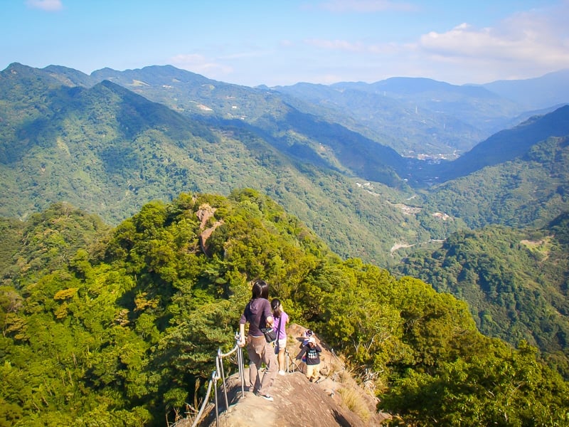
Four Beasts refers to four connecting peaks named after animals on the eastern edge of Taipei City. They are Elephant Mountain, Tiger Mountain, Leopard Mountain, and Lion Mountain. Collectively they are located on Nangang Mountain.
Elephant Mountain (象山 or Xiangshan) in particular is the most famous hike in Taipei. It’s great for those enjoying some solo travel in Taiwan since it’s popular and you likely won’t go too long without seeing another person.
It only takes 20 minutes up a series of steep stairs to reach an incredible, panoramic view of Taipei City dominated by Taipei 101, which is only 1.2 kilometers (0.7 miles) away.
If you’ve ever seen a postcard of Taipei, it was probably shot from here!
From the famous — and extremely crowded, especially at sunset — viewpoint on Elephant Mountain (the exact point is called 象山六巨石觀景台), the trail connects to a network of other Taipei hiking trails on the other three mountains.
These are far less crowded but also offer incredible views over Taipei.
A longer and more difficult trail continues all the way up to the peak of Nanshan Mountain.
2. Seven Star Mountain
Trail Difficulty: Moderate
Trail Length: 4.5 kilometers (2.8 miles)
Location: Yangmingshan National Park, Taipei City
Trailhead: The trail begins at Xiaoyoukeng Visitor’s Center in Yangmingshan National Park, Beitou District, on the northwestern side of the mountain. It is also possible to hike to the peak from Lengshuikeng hot spring on the southeaster side of the mountain. Both starting points have connections by bus to the city center.
Trail Map: Click here for a Seven Star Mountain trail map
About this Taiwan Trail:
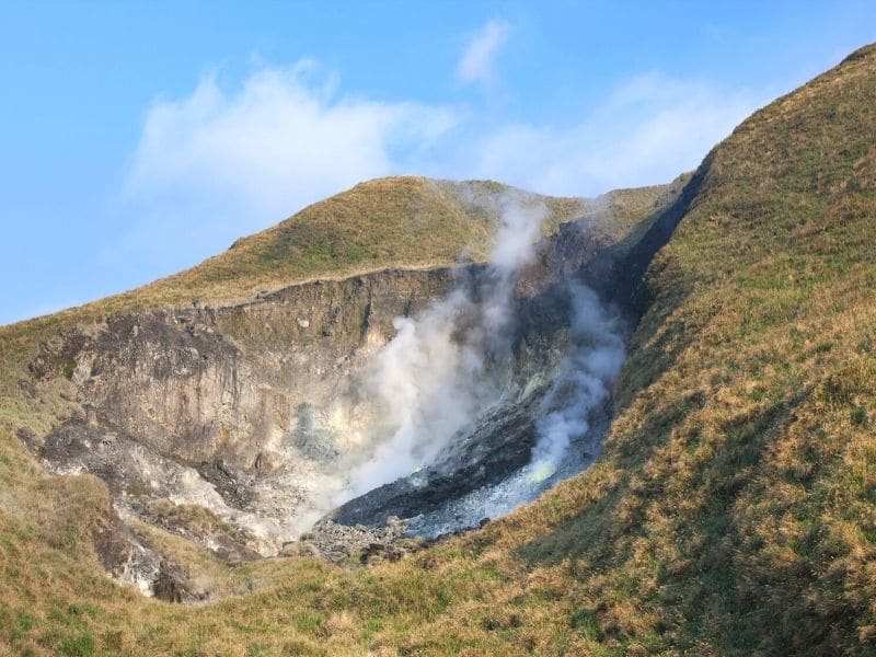
Seven Star Mountain (七星山 or Qixingshan) is the tallest peak in Yangmingshan National Park at 1120 meters (3,675 feet).
It is part of a large volcanic massif right on the edge of Taipei City and is a great place to take in the beauty of the Taiwanese mountains.
The hiking trail begins at Xiaoyoukeng, where you’ll walk right past steaming fumaroles on the side of the volcano. To your legs: prepare for lots of stairs!
The Qixingshan Main Peak is covered in grasslands that are often covered in mist, and on clear days, you can see all the way to the ocean from the top.
Instead of backtracking to Xiaoyoukeng, a more interesting descent is down the other side to Lengshuikeng, a simple public hot spring.
Besides the Main Peak, it’s also possible to add side trips to the South Peak and East Peak.
Fun Fact:
Qixingshan is the tallest dormant volcano in Taiwan, although recent studies show that it may not actually be dormant!
3. Pingxi Crags
Trail Difficulty: Moderate
Trail Length: 2.4 kilometers (1.5 miles)
Location: Pingxi District, New Taipei City
Trailhead: The trailhead is a 300-meter (984-foot) walk from Pingxi train station on the Pingxi Small Railway Line. You can access this scenic railway line from Taipei by transferring at Ruifang Station. The trailhead is Jing An Road right beside the Pingxi Waterfall lookout.
Trail Map: Click here for a Pingxi Crags trail map
About this Taiwan Trail:
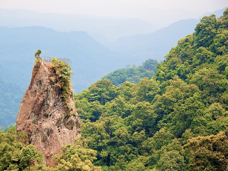
Pingxi Crags (平溪小三尖) refers to three extremely vertical rocky crags that stick up hundreds of meters into the sky.
The three crags are called Xiaozi Mountain (孝子山), Putuo Mountain (普陀山), and Cimu Peak (慈母峰), and the trail is sometimes also called Xiaozishan Trail after the first one.
Each of the three crags can be summited on ladders. While none of them is particularly difficult, simply looking down can be scary, especially for those with vertigo. This is what makes it one of the most exhilarating yet doable hikes in Taiwan.
Fun Fact:
Pingxi village is one of the locations of the famous mass sky lantern release on the 15th day of the first month of the lunar calendar. The other location is nearby Shifen, which has the most famous waterfall in Taiwan.
4. Wuliaojian Trail, New Taipei City
Trail Difficulty: Difficult
Trail Length: 4.8 kilometers (3 miles)
Location: Sanxia District, New Taipei City
Trailhead: The trail is located 6 kilometers (3.7 miles) south of Sanzia District, which is popular for Sanxia Old Street and Zushi Temple. Take bus 807 from Sanxia (up to 30 minutes) or just hop in a taxi (10 minutes).
Trail Map: Click here for a Wuliaojian Trail map
About this Taiwan Trail:
Like the last entry, Wuliaojian Trail (五寮尖) is one of the most exciting hiking trails in Taiwan that can be done in a single day. And also like the Pingxi Crags, it’s easily reachable from Taipei City.
It’s one of the best places to hike in Taiwan!
What makes this trail so fun is the sheer variety of terrain you’ll encounter. You’ll need to climb ropes and ladders up rock walls, squeeze through gaps, and follow a narrow ridge. For this reason, many local hikers cite Wuliaojian as their favorite hike in all of Taiwan.
Because of the verticals, ropes & ladders, and the fact that you’ll need to use your hands a lot, this hike is considered difficult, but anyone in decent shape and with some hiking experience should be able to handle it.
No additional equipment is required, but it’s best to go with a group of fellow hikers.
5. Teapot Mountain
Trail Difficulty: Moderate
Trail Length: 3.5 kilometers (2.2 miles)
Location: Jinguashi, New Taipei City
Trailhead: The trail can be accessed directly from the Jinguashi Gold Ecological Park in New Taipei City. There’s a small entrance fee for the Gold Ecological Park, and the park is worth seeing, but if you only want to do the hike, you can inform the ticket desk and they will probably let you through without paying the fee.
Trail Map: Click here for a Teapot Mountain trail map
About this Taiwan Trail:
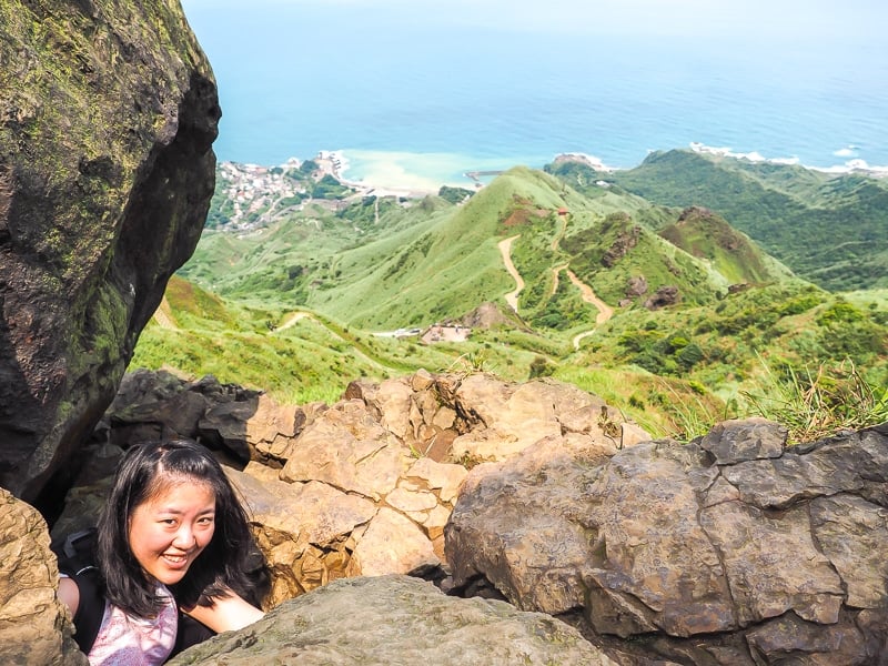
One of the most beautiful coastal hikes in Taiwan, Tea Pot Mountain (茶壺山) is a small mountain with a large stony peak that is shaped like (you guessed it) a teapot.
The trail begins in the Jinguashi Gold Ecological Park, which is just a few minutes by bus from Jiufen, a very popular day trip from Taipei. For the first part of the hike, the views looking down at the coast just get better and better.
But the most exciting part of the hike is when you reach the teapot itself, which has a cave that you’ll have to climb down into and out to the other side.
After that, the trail reaches a small rock wall with a ladder, after which it circles back to Jinguashi.
6. Caoling Historic Trail
Trail Difficulty: Moderate
Trail Length: 7.1 kilometers (4.4 miles)
Location: New Taipei City & Yilan County
Trailhead: You’ll need to get to a spot called Yuanwangkeng Entrance on Google Maps, which is about 30 minutes on foot from Fulong train station by Fulong Beach. If you walk in the opposite direction, the trail starts right inside Dali Temple (大里天公廟).
Trail Map: Click here for a Caoling Historic Trail map
About this Taiwan Trail:
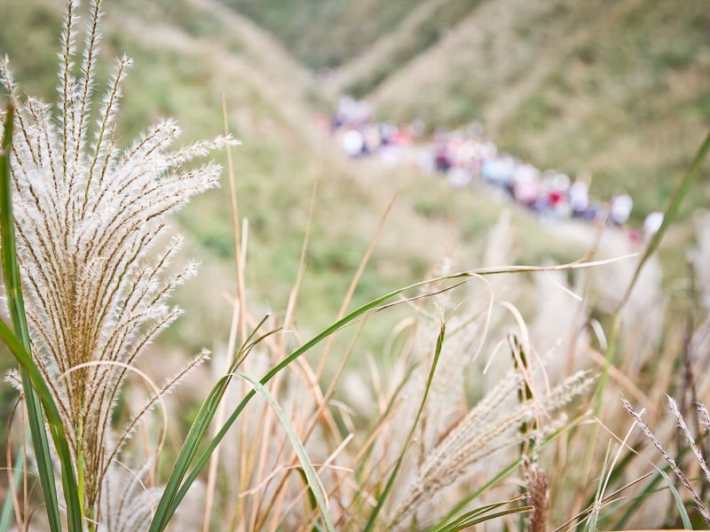
The Caoling Historic Trail (草嶺古道) was once the only route connecting the northeast coast of Taiwan to the Yilan plains.
Today it is especially famous for its coastal bluffs and seas of silvergrass, which paint the slopes silver in autumn.
The trail ascends through the forest, where it passes a few historic structures, before reaching dramatic Pacific Ocean views from a series of coastal bluffs. From there, the trail descends quickly to a beautiful temple on the coast in Dali.
An optional add-on is to follow the Taoyuan Valley Trail along the coast and finish in Daxi. It’s an up-and-down slog that makes for a very long day, but comes with incredible views and no crowds.
You are also likely to see wild buffalo grazing in the elevated grasslands.
If you do the hike in the opposite direction, starting at Dali, you can finish off at Fulong Beach, the best beach in northern Taiwan.
Fun Fact:
Lonely Planet once wrote that if you can only do one hike in Taiwan, make it this one.

7. Lion’s Head Mountain
Trail Difficulty: Easy
Trail Length: 3.5 kilometers (2.2 miles)
Location: Hsinchu & Miaoli Counties
Trailhead: To reach the Lion’s Head Mountain Visitor’s Center on the Miaoli side, take bus 5700 (hourly on the hour from 8 am to 2 pm) from Hsinchu train station. On the Miaoli side, there’s no public transportation, but bus 5805 from Zhunan will get you close. If you can, getting there on your own by scooter is best.
Trail Map: Click here for a Lion’s Head Mountain trail map
About this Taiwan Trail:
Lion’s Head Mountain (獅頭山 or Shitoushan) is a short mountain, only 492 meters (1,614 feet) at its highest point. The slopes of the mountain are, however, rich in Buddhist and Taoist culture, making it a fascinating day hike.
The main trail at Lion’s Head Mountain, called Shishan Historic Trail, goes from the Lion’s Head Mountain Visitor’s Center on the north (Hsinchu) side of the mountain to Quanhua Temple on the south (Miaoli) side of the mountain.
Along the way, the trail passes over a dozen or so active Buddhist and Taoist temples and monasteries where many monks and nuns reside. Some of the temples are even built into caves.
The most interesting temples are on the Miaoli side, so you can also start and finish your hike there. It is also possible to spend the next in one of the guest rooms at Quanhua Temple, which have quite a view. Simple vegetarian meals are served from the temple’s kitchen.
8. Snow Mountain (Xueshan)
Trail Difficulty: Difficult
Trail Length: 7.4 kilometers (4.6 miles)
Location: Shei-Pa National Park, Taichung City
Trailhead: The trail is accessed from near Wuling Farm, a resort town popular for flower viewing.
Trail Map: Click here for a Snow Mountain trail map
About this Taiwan Trail:
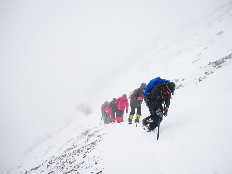
Snow Mountain (雪山 or Xueshan, also known as Mount Sylvia) is the second-highest peak in Taiwan at 3,886 meters (12,749 feet).
It lends part of its name “Xue” to the national park name, Xueba National Park (also spelled Shei-Pa National Park), along with another iconic mountain peak in the park, Dabajianshan, also spelled Da “pa” jiashan.
It can be hiked year-round, and in winter, offers one of the best opportunities to see, as the name suggests, snow in Taiwan.
You won’t just see a little snow on the peak of Snow Mountain; you may be hiking through it up to your knees. You’ll also see stunning icicles and other snow and ice formations, as well as the awe-inspiring Black Forest.
If you want to go hiking in the snow, the best months to go are December through March, with January and February being the most likely. Temperatures can plummet well below zero, so obviously proper clothing and hiking gear is needed, but no specialized rock or ice climbing equipment is required.
The hike usually takes two nights; on the first day, a short hike will bring you to Qika Cabin, while a longer second day brings you to 369 Cabin. On the third day, you can summit and return to the bottom of the mountain.
To do this popular hike, you’ll need national park permits and cabin reservations. Going with a local English-speaking group like Taiwan Adventures is highly recommended.
Fun Fact:
Snow Mountain is also the starting point of a very difficult, five-to-six day hike across the peaks of several 3000+ meter peaks called the Holy Ridge.
If you’re looking for the best multi day hikes in Taiwan, this trek should be on your list!
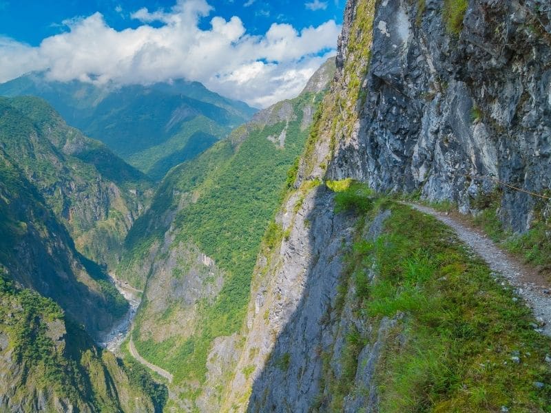
9. Zhuilu Old Trail
Trail Difficulty: Difficult
Trail Length: 6 kilometers (3.7 miles)
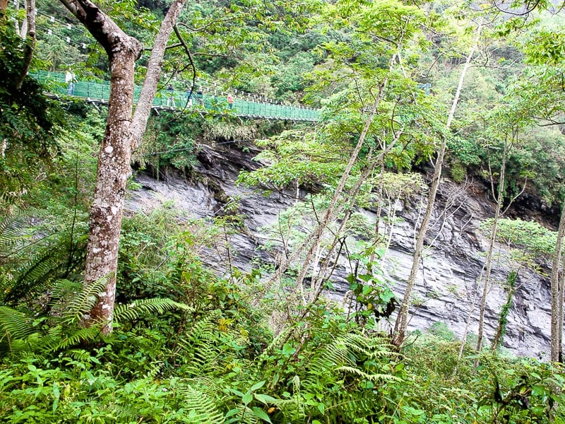
Location: Taroko National Park, Hualien County
Trailhead: The trail is located in Taroko Gorge, one of Taiwan’s most famous natural attractions. The trailhead is accessed by crossing a bridge at Swallow’s Grove, one of the popular stops inside Taroko Gorge.
Trail Map: Click here for a Zhuilu Old Trail map
About this Taiwan Trail:
Zhulu Old Trail is renowned for its ultra-narrow (less than a meter) paths with 750-meter (2,461-foot) drops on one side to the canyon floor below.
And no, there aren’t any rails.
The path was originally built in the 1800s as a hunting trail by the local Truku aboriginal tribe, who lend their name to Taroko Gorge. If the trail seems narrow now, it was only one-third as big when they first made it!
Today the trail is located within Taroko National Park and starts from one of the park’s most well-known scenic spots, though few people realize this when stopping there.
Because of the obvious risks, permits are required for this one, and they aren’t easy to get. Therefore, going with an experienced and English-speaking local guide is recommended. I recommend Island Life Taiwan for this one.
10. Walami Trail
Trail Difficulty: Moderate
Trail Length: 4 to 11.2 kilometers – short and long options (2.5 to 7 miles)
Location: Yushan National Park, Hualien County
Trailhead: The trail begins near Nan An Waterfall just outside of Yuli town in southern Hualien County. The easiest way to get there is by renting a scooter at Yuli train station.
Trail Map: Click here for a Walami Trail map
About this Taiwan Trail:
Immerse yourself in Taiwan wilderness on this unforgettable trek!
Walami Trail begins in the typical jungle landscape of Hualien County, complete with the chance to see lots of macaques.
Most day hikers go as far as Shanfeng Waterfall. This portion of the trail is rated easy and can be done in a few hours without a permit.
From there, the trail ascends into the high mountains of Yushan National Park toward Yushan, Taiwan’s tallest mountain (see next entry).
To do the full hike, which usually involves spending a night at Walami Cabin, two permits are required.
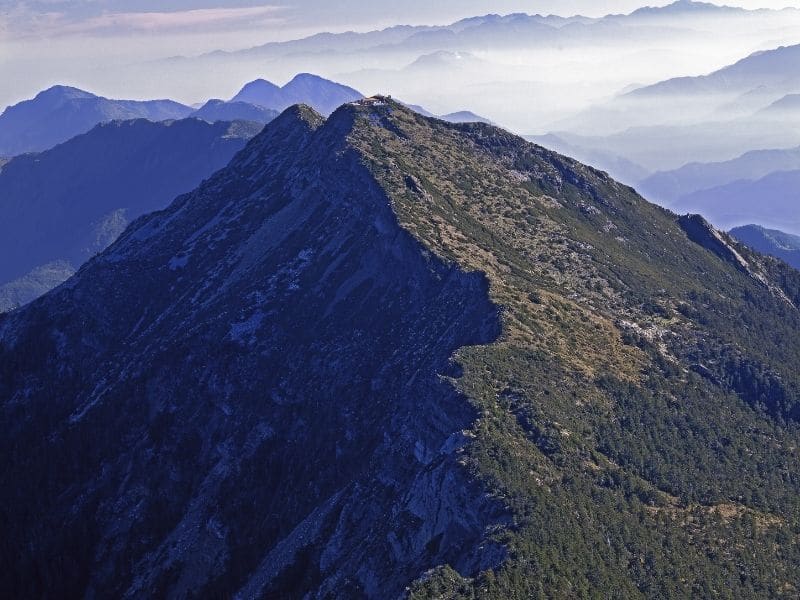
11. Yushan Peak
Trail Difficulty: Difficult
Trail Length: 24.3 kilometer (15 miles)
Location: Yushan National Park, Nantou County
Trailhead: The trail begins at Dongpu Lodge in Tataka, which is located on the mountain road connecting Alishan and Sun Moon Lake, two of Taiwan’s most popular attractions.
Trail Map: Click here for a Yushan Peak trail map
About this Taiwan Trail:
If it’s true adventure travel you seek, this trail should be on your radar, as it’s one of the best hikes in the world and is a challenge, as well.
Yushan (玉山, also called Jade Mountain) is the highest peak in Taiwan and Northeast Asia at 3,952 meters (12,966 feet), which is 176 meters (577 feet) taller than Mt. Fuji in Japan.
Yushan National Park contains more than 30 peaks above 3000 meters (9,843 feet) and is abundant in wildlife and fauna. Despite its large size, the park is relatively remote and inaccessible.
The hiking trail to the peak of Yushan is rated difficult but can in fact be done with anyone with moderate hiking experience, even older children or young teenagers.
Many people spend the night at Dongpu upon arriving, then begin the ascent the next morning. They spend the second night at Paiyun Lodge, then rise early to take in the sunrise from Yushan Peak.
It is common to witness a sunrise above a sea of clouds in the valleys far below from Yushan Peak, a phenomenon that is also associated with the nearby Alishan National Scenic Area.
Permits and cabin reservations are necessary for this one. There are strict caps on how many people can hike every day. Because of this — as well as the hike’s immense popularity — you’ll have to book well in advance. Going with a guided group such as Taiwan Adventures is highly recommended.
If you’re looking for something truly memorable to add to your Asia travel itinerary, you certainly won’t forget this incredible hike!
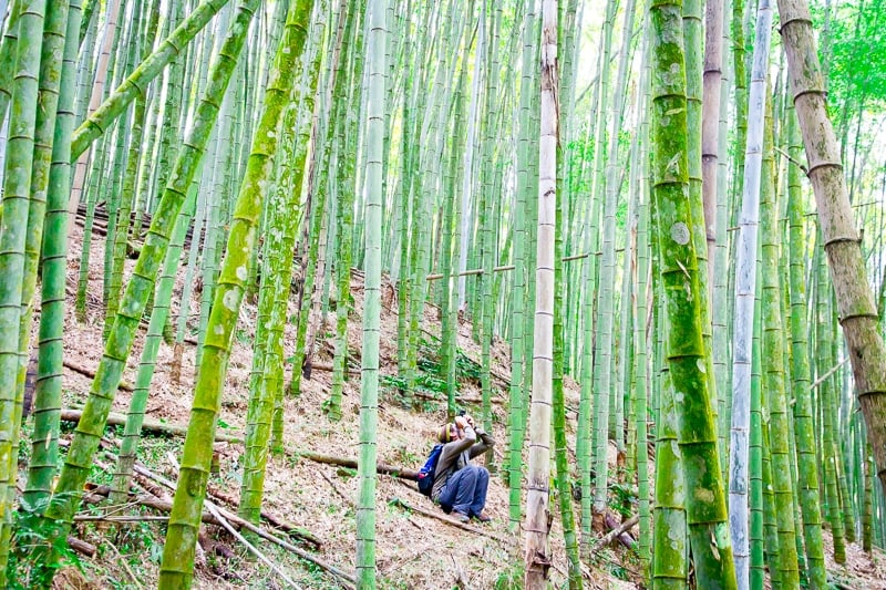
12. Ruitai Historic Trail
Trail Difficulty: Moderate
Trail Length: 6.4 kilometers (4 miles)
Location: Chiayi County
Trailhead: This one-way trail begins in the small mountain village of Ruili (瑞里) and ends in another small village of Taihe (太和), which is near Fenqihu, a small tourist town on the famous Alishan Forest Railway. It can also be done in reverse. Minibuses from Chiayi City to Ruili are infrequent, with only a few per day.
Trail Map: Click here for the Ruitai Historic Trail
About this Taiwan Trail:
This historic trail in the hunting grounds of the local Tsou aboriginal tribe is one of the best ways to admire bamboo forests and take in beautiful Taiwan nature.
Almost the entire trail runs through bamboo forest, so you’ll be surrounded by towering, swaying stalks of bamboo.
The trail is relatively unknown, especially compared to the very famous and crowded hiking trails in Alishan National Scenic Area nearby. You can expect to encounter few to no other hikers on this one.
Because there are so few buses to Ruili, it’s important to plan your transportation to and from the trail.

13. Monkey Mountain (Shoushan), Kaohsiung
Trail Difficulty: Easy – Moderate
Trail Length: 5.1 kilometers (3.2 miles)
Location: Kaohsiung City
Trailhead: The trail begins behind Longquan Temple (萬壽山龍泉禪寺), northwest of the Kaohsiung city center. There are a network of trails covering Shoushan (AKA Monkey Mountain) and adjacent Chaishan to the south.
Trail Map: Click here for a Monkey Mountain trail map
About this Taiwan Trail:
While there are fewer well-known hiking trails in the far south of Taiwan, one that stands out is Monkey Mountain in Kaohsiung City.
Monkey Mountain is named for the fact that you are pretty much guaranteed to see troops of macaques there.
There is a vast network of hiking trails covering Shoushan and Chaishan mountains, but a popular circuit involves going up to Monkey Rock and back.
If you just want to see the macaques, you don’t have to walk far in to see them, so this hike could be short and rated easy.
Because the macaques are used to humans, they are rather fearless and known to grab items from people. Caution should be taken, and never feed the macaques.

Best Hotels In Taiwan
Looking for where to relax after going on one of Taiwan’s best hikes?
➡️ Click here to browse hotels in Taiwan!
Prefer self-contained stays?
➡️ Click here to check out unique local rentals!
You can also use this map to search for local stays:
Renting A Car In Taiwan
One of the best ways to get around — especially if you’re looking to do a few different Taiwan hiking trails — is to rent a car.
Use Discover Cars to quickly compare your car rental options.
Their comparison tool does the homework for you, so there’s no need to have up 10+ tabs trying to figure out which company is the most affordable. Actually, you can save up to 70% using their tool!![]()
Active Tours In Taiwan
Along with doing the above Taiwan hikes, here are a few fun and adventurous tours:
- Taipei City Bike Tour with Elephant Mountain Hiking Experience
- Full-Day Private Northern Taiwan Tour from Taipei with Pickup
- One Day Hike around Taipei’s Yangmingshan National Park from Taipei
➡️ Click here for a full list of tours.
Taiwan Travel Insurance
When visiting Taiwan — or anywhere else in the world — make sure to get travel insurance.
In my opinion, the best travel medical insurance for travelers is SafetyWing as they’ve got a large network and offer both short-term and long-term coverage — including coverage if you’re traveling for months as well as limited coverage in your home country).
Additionally, SafetyWing is budget-friendly and offers $250,000 worth of coverage with just one low overall deductible of $250.
Click my referral link here to price out travel insurance for your trip in just a few clicks.
What best hiking trails in Taiwan would you add to this list?
Pin this Taiwan hiking guide for later