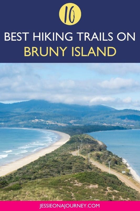
10 Amazing Bruny Island Hikes Not To Be Missed
This post contains affiliate links, including Amazon affiliate links. If you purchase through these links, I may earn a commission at no extra cost to you. As an Amazon Associate, I earn from qualifying purchases. Thank you for your support!
By Kelli Lovett. This post on Bruny Island walking tracks contains affiliate links to trusted partners!
Looking for epic Bruny Island hikes?
Then you’re in the right place!
Desolate beaches, soaring sea cliffs, secret coves, coastal forest, and abundant (but elusive) native animals make Bruny Island in Tasmania, Australia an outdoor enthusiast’s dream.
With scarce development and a large portion of the island dedicated to South Bruny National Park, the best way to explore is on foot.
Luckily, we’ll be going over some of the best walks on Bruny Island in Tasmania, Australia and how to experience them for yourself.
Quick tip: Whether you’re hiking solo or in a group, it’s smart to keep safety in mind. One piece of advice is to carry a She’s Birdie Personal Safety Alarm, which features a 130db alarm and flashing strobe light designed to deter an attack. It’s a top safety essential whether hiking, at home, or traveling.

But, first, a bit about Bruny:
Known as Lunnawannalonna by the Indigenous Nuenonne people who have lived there long before European settlement, many Aboriginal people still live on the island today.
In the early-to-mid-1800s, a number of whaling stations were erected on Bruny Island. In 1838, Australia’s second oldest lighthouse was erected. Later, the island was used for logging. Ports, jetties, and tramways were built to support the timber industry. Logging is still carried out in the interior of the island.
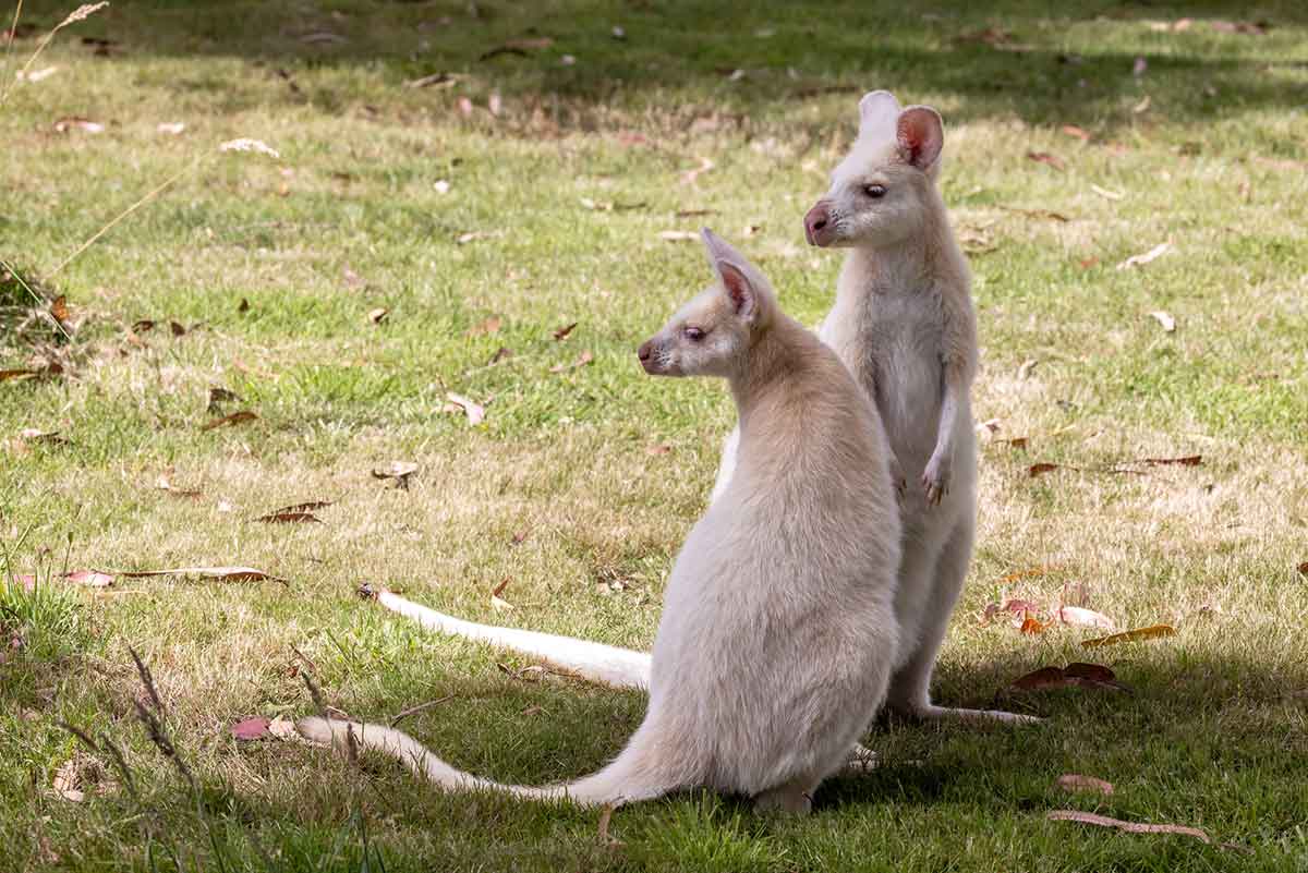
Since the early 1900s, Bruny has been a popular tourist destination. Today it is known for its opportunities to see birds and other wildlife like seals, penguins, and the rare white wallaby.
Bruny Island is also popular for its local produce and farm-to-table experiences with a local vineyard, a beer and cheese factory, and an oyster farm all found on the island.
Above all, Bruny Island offers a wilderness experience characterized by temperate rainforest, eucalypt forest, and coastal scrub surrounded by a spectacular coastline showcasing sea cliffs, sheltered bays, and open stretches of beach.
It is truly a bushwalker’s paradise with adventures suitable for every level. And for those whose adventure of choice is hiking, keep reading for 10 of the best Bruny Island hikes you don’t want to miss.
What Type Of Hiker Are You? [Free Quiz]
But first, before we dive into some unforgettable Bruny Island walking tracks, I want to share a free personality quiz I think you’ll love!

Discover your hiking persona in this fun and short hiker personality quiz, which also shares trail suggestions based on your results.
Once you’ve grabbed the quiz, let’s discuss some not-to-miss Bruny Island bush walks. The island is a must-visit destination for outdoor enthusiasts traveling Australia!
Bruny Island Map
Before going hiking on Bruny Island in Tasmania, it’s recommended to check out a map to get a lay of the land.
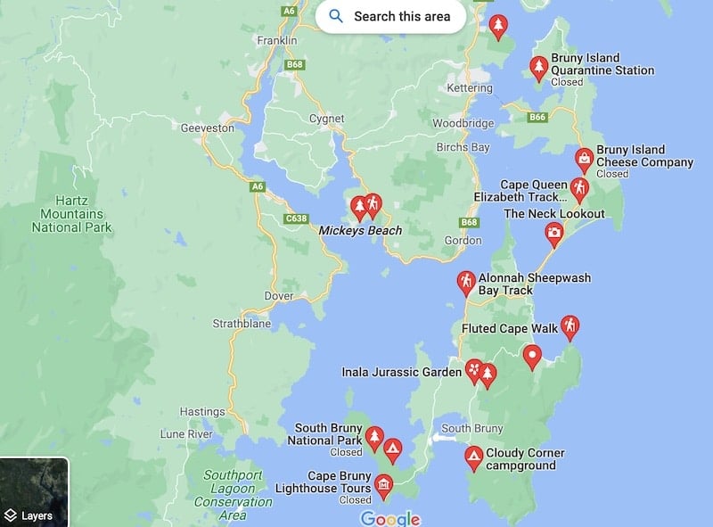
The above Bruny Island walks map offers a great place to start, or you can click here for the interactive Google Maps version.
Best Bruny Island Hikes
Bruny Island Short Walks
The Bruny Island short walks included below range from 0.3 to 6.3 kilometers (0.2 to 4 miles), taking between 20 minutes and 2.5 hours to complete.
1. Mavista Nature Walk
Trail Difficulty: Easy
Length: 2.1 kilometers (1.3 miles)
Location: Mavista Picnic Area & Walking Track, Resolution Rd, Adventure Bay TAS 7150, Australia
Trailhead: This walk begins from a small picnic area along Resolution Road, behind Adventure Bay.
Trail Map: Click here for a trail map of the Mavita Nature Walk.
About This Bruny Island Trail:
This short trail in the Water Fall Creek State Reserve takes walkers through lush Tasmanian temperate rainforest.
The trail follows Water Fall Creek under stringybark, tree ferns, and blackwoods. The shady, cool, and wet environment means leeches may be lurking so make sure to fully cover up to avoid bringing a surprise visitor back with you.
This Bruny Island walk is great for families, solo hikers, or those looking for a shorter walk as this trail can be easily completed in 30 to 40 minutes.
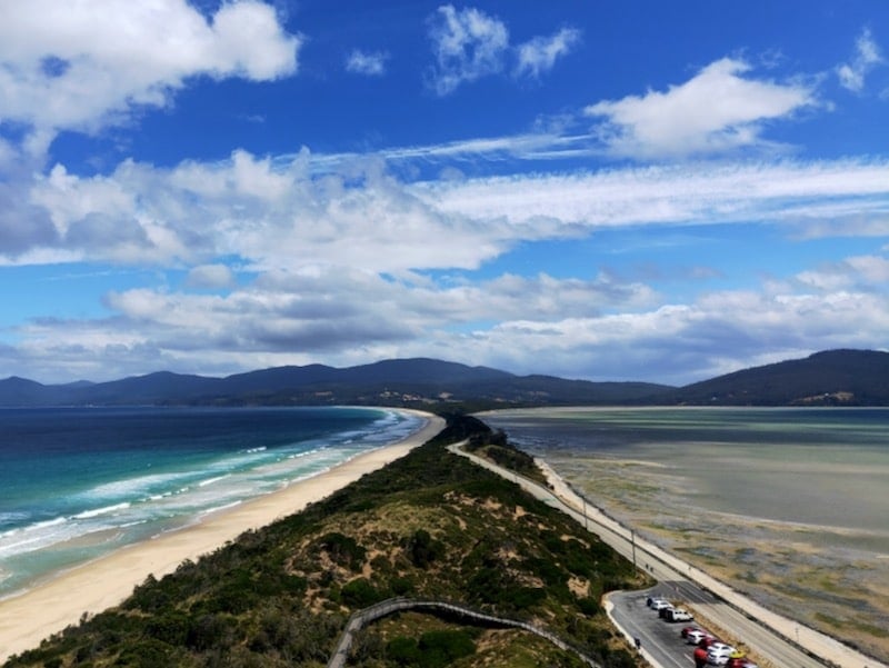
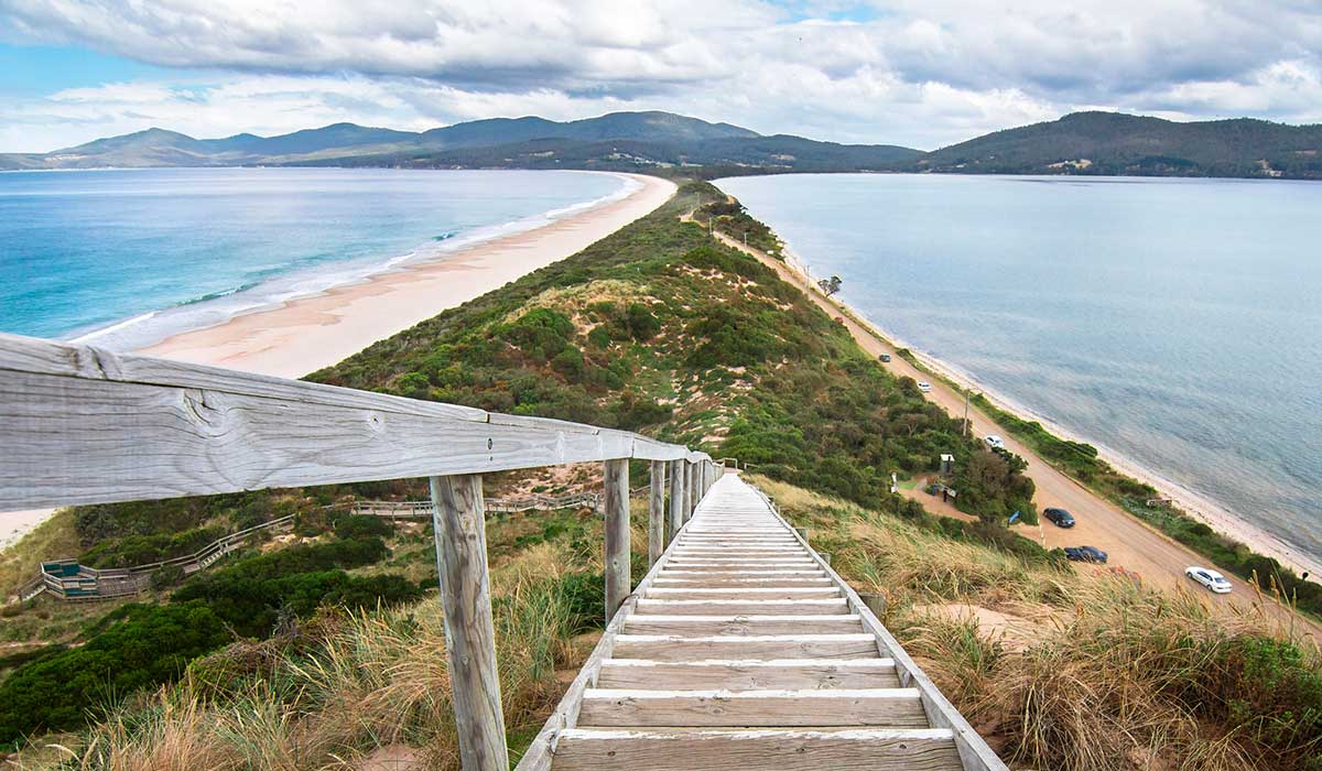
2. Truganini Memorial & The Neck Lookout
Trail Difficulty: Easy
Length: 0.3 kilometers (0.2 miles)
Location: The Neck, Bruny Island Main Rd, South Bruny TAS 7150, Australia
Trailhead: The Neck car park can be found along the Bruny Island Main Road, along the narrow isthmus that connects North and South Bruny Island. The walk begins from the car park.
Trail Map: Click here for a trail map of the Truganini Memorial & The Neck Lookout hike.
About This Bruny Island Trail:
This short walk up wooden stairs to a viewing platform provides awesome 360-degree views of the narrow isthmus known as “The Neck” that connects North and South Bruny Island. You’ll also have a fantastic vantage to see the bays, beaches, and rugged headlands of Bruny.
The Neck is one of the most famous sights on the island, an impossibly thin sliver of land connecting the islands, the sea on either side threatening to wash away the strip of sand and road. This iconic view is one of the most beautiful spots on Bruny and a great place to stop and stretch your legs.
A monument at the top of the viewpoint is dedicated to the Nuenonne tribe who inhabit Lunnawannalonna and to Truganini, a daughter of tribe elder Mangana.
At the beginning of the trail near the car park, you can also access the beach and observation platforms where fairy penguins can be seen returning home in the evenings under the cover of darkness.
3. Alonnah-Sheepwash Bay Track
Trail Difficulty: Easy
Length: 3 kilometers (1.9 miles)
Location: Mavista Picnic Area & Walking Track, Resolution Rd, Adventure Bay TAS 7150, Australia
Trailhead: This walk begins from a small picnic area along Resolution road, behind Adventure Bay.
Trail Map: Click here for a trail map of the Alonnah-Sheepwash Bay Track.
About This Bruny Island Trail:
Another easy walking trail suitable for all walkers is the Alonnah-Sheepwash Bay Track.
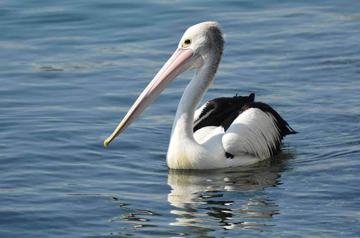
This coastal trail takes walkers along the foreshore between Allonah and Sheepwash Bay, showcasing a landscape dominated by coastal bushland and wetlands with birds including pelicans, cormorants, and herons.
The track was originally used by loggers and still has evidence of early settler occupation. For example, near Sheepwash Creek you can find remnants of a sawyer’s camp – a camp for people who saw wood that was prodominate in the area early on – near the main track.
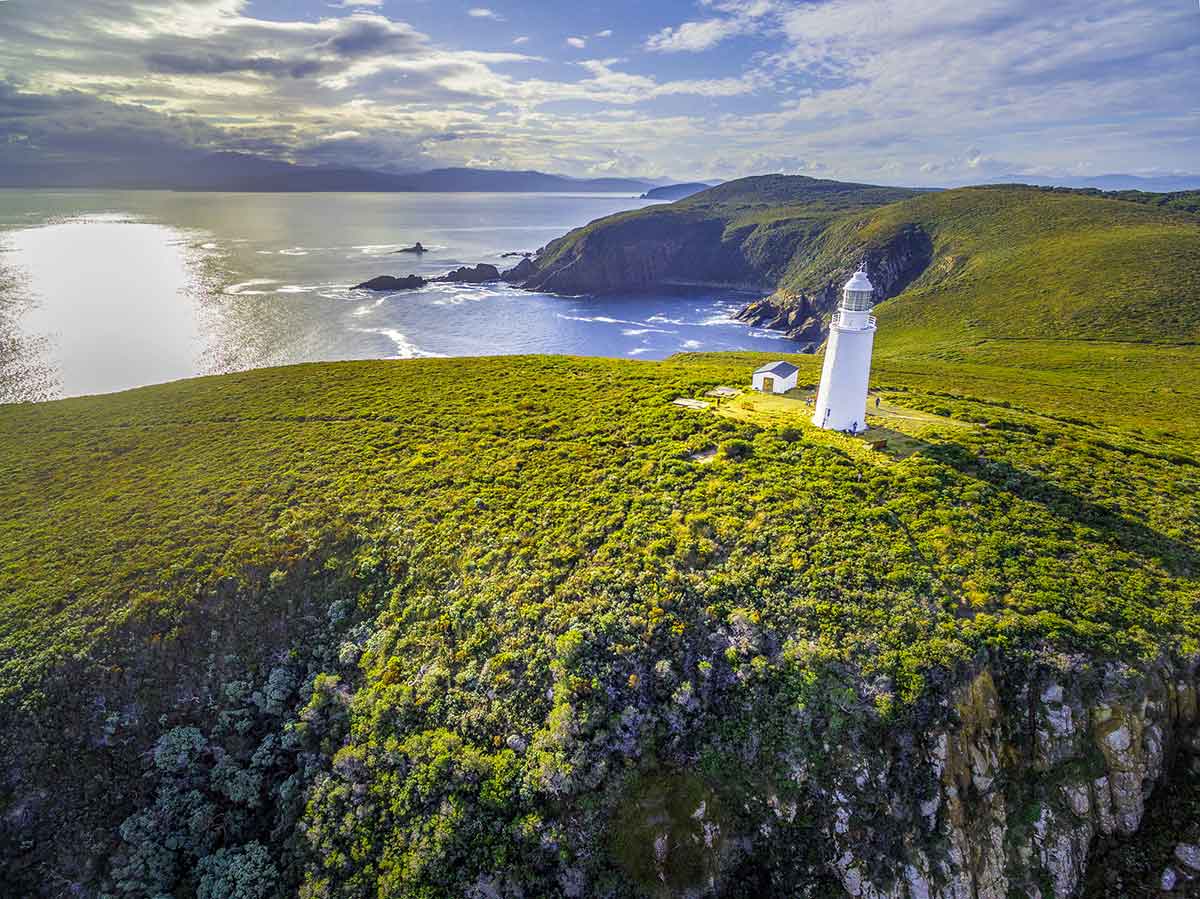
4. Cape Bruny Lighthouse
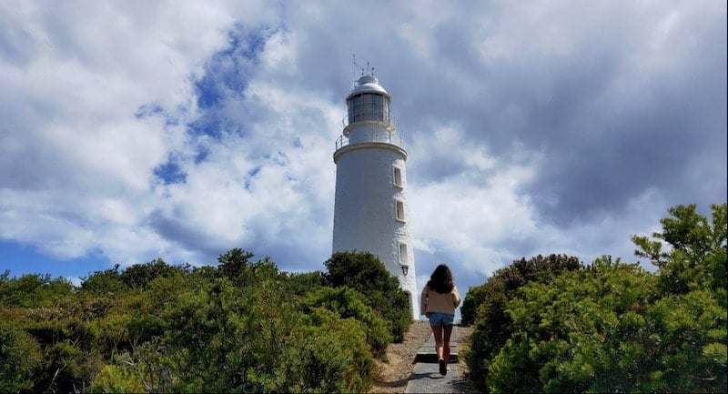
Trail Difficulty: Easy
Length: 1.6 kilometers (1 mile)
Location: 1750 Lighthouse Rd, South Bruny TAS 7150, Australia
Trailhead: Two tracks lead out from the Cape Bruny Lighthouse car park; one up the lighthouse and another access track down to the Lighthouse Bay Beach.
Trail Map: Click here for a trail map of the Cape Bruny Lighthouse hike.
About This Bruny Island Trail:
Standing atop the rugged sea cliffs of Cape Bruny, watching out over a dark and angry sea, it’s not hard to imagine the shipwrecks that led to the construction of the lighthouse here in 1836.
Beginning from the car park, a short and steep 300-meter climb takes walkers to the base of Australia’s second oldest lighthouse. Established after a number of ships went down in the treacherous waters off Cape Bruny, it remained in service until 1996.
Today, it is possible to take a guided tour inside the lighthouse and visit a small museum found in the lighthouse station next to the car park.
From the lighthouse, return to the car park and climb down to Lighthouse Bay along the 500-meter access track. Along the way, a cemetery and old walled vegetable garden can be found.
The exposed Cape Bruny Lighthouse is usually very windy so dress warmly and pack a rain jacket.
5. Grass Point
Trail Difficulty: Easy
Length: 4 kilometers (2.5 miles)
Location: Fluted Cape Parking Area, Adventure Bay TAS 7150, Australia
Trailhead: These walks begin behind the right side of the beach at Adventure Bay.
Trail Map: Click here for a trail map of the Grass Point hike.
About This Bruny Island Trail:
The Grass Point hiking trail is perfect for an early morning or late evening stroll. The wide, flat surface makes this trail suitable for all ages and all levels.
The trail hugs the coastline and offers beautiful views over Adventure Bay under a canopy of gum trees. When you reach Grass Point you will have views back over Adventure Bay and further onward to Penguin Island.
Unfortunately, the fairy penguins for which Bruny Island is famous don’t live on this part of the island. That being said, if you are visiting between the months of June and October you should keep your eyes peeled for southern right whales, which can be seen migrating in these waters.
To return, follow the same path back to the car park. The return journey should take between 1 to 1.5 hours to complete.
6. Fluted Cape Walk
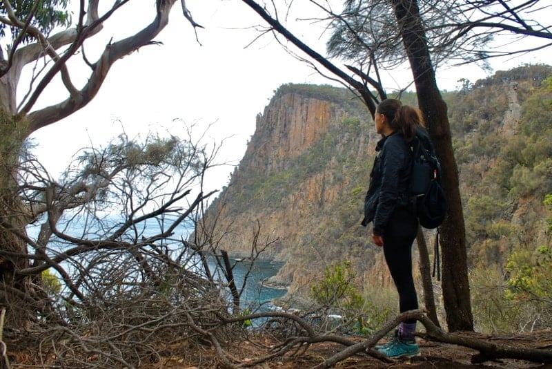
Trail Difficulty: Moderate
Length: 6.3 kilometers (3.9 miles)
Location: Fluted Cape Parking Area, Adventure Bay TAS 7150, Australia
Trailhead: These walks begin behind the right side of the beach at Adventure Bay.
Trail Map: Click here for a trail map of the Fluted Cape Walk.
About This Bruny Island Trail:
Listed as one of Tasmania’s 60 Great Short Walks by Parks & Wildlife Service Tasmania, this moderately trafficked trail is easily one of the best Bruny Island hikes.
The Fluted Cape Trail follows the same path as the Grass Point Trail; however, after reaching Grass Point, you must begin the ascent to the top of the 272-meter sea cliffs.
While short, the uphill climb is arduous. The views along the way to the top of the sea cliffs, however, make the trek worth every drop of sweat.
One of the most unique aspects of the Fluted Cape hike is the views from the top of the sea cliffs. In the distance looking north, you will be able to see the sea cliffs of Cape Raoul and Cape Pillar along the famed Three Capes Track on the Tasman Peninsula.
On the trail, don’t forget to keep an eye out for the rare and elusive white wallaby. If you spot a white-furred wallaby peering at you from the underbrush, you’re witnessing some of Australia’s only albino wallaby population.
Without predators on the island, a genetically unique population of Bennetts Wallabies has thrived here. Keep your camera handy in case you are lucky enough to see one of these incredible creatures.
Those hiking the Fluted Cape Trail should complete the loop in a clockwise manner at the request of the national park service. While doing the trail clockwise may be more challenging, you will be protecting the environment from the spread of unwanted disease for future hikers.
The Fluted Cape track should take between 2 to 2.5 hours to complete.
7. Luggaboine Circuit Walking Track
Trail Difficulty: Easy
Length: 5 kilometers (3.1 miles)
Location: Roberts Point, Bruny Island
Trailhead: This walk begins from the Jetty Beach camping area on the western end of the campgrounds.
Trail Map: Click here for a trail map of the Luggaboine Circuit Walking Track.
About This Bruny Island Trail:
If you do not have enough time to complete the full Labillardiere Peninsula Circuit, then the Luggaboine Circuit Walking Trail is perfect for you. Another Bruny Island hike that is suitable for all ages, this trail is designated as easy.
Much of the circuit includes walking through the coastal bush and along the beach.
Highlights of the Luggaboine Circuit include a lovely secluded beach with crystal clear water, an abundance of birds and wildlife for avid nature lovers, and unforgettable views back over the southern coast of mainland Tasmania.
Longer Bruny Island Hikes
Looking for a more intense adventure travel experience? These longer Bruny Island hikes range between 12 to 18 kilometers (7.5 to 11.2 miles) and require more than 3 hours to complete the return journey.
8. East Cloudy Head Track
Trail Difficulty: Moderate
Length: 12 kilometers (7.5 miles)
Location: Cloudy Bay, TAS 7150, Australia
Trailhead: This walk begins at the end of Cloudy Bay Road.
Trail Map: Click here for a trail map of the East Cloudy Head Track.
About This Bruny Island Trail:
Located in South Bruny National Park, this out-and-back Bruny Island walk offers panoramic views over Cloudy Bay and the surrounding area. Those who visit on a clear day even have the chance to see Mount Wellington near Hobart and the Southern Ranges.
The trail begins with a 4-kilometer (2.5-mile) walk along Cloudy Bay Beach.
From here, the hike follows an old 4WD track over 2 kilometers (1.2 miles) and up 300 meters to the headland for some of the best views off the coast of South Bruny Island.
Hikers can choose to continue to the arch on Moorina Bay via the beach at low tide or via Mars Bluff. The track is poorly marked, so it is advised to use GPS to monitor your location during the hike.
9. Cape Queen Elizabeth Track
Trail Difficulty: Moderate
Length: 12.6 kilometers (7.8 miles)
Location: Across the street from Bruny Island Honey.
Trailhead: This walk begins along the Bruny Island Main Road across the street from Bruny Island Honey.
Trail Map: Click here for a trail map of the Cape Queen Elizabeth Track.
About This Bruny Island Trail:
One of the most popular Bruny Island hikes is the Cape Queen Elizabeth Track.
Centrally located just before “The Neck”, this track navigates the bushlands of South Bruny Island passing two lagoon – the Big Lagoon and Small Lagoon – before reaching a white silica sand beach.
Once you reach the beach, continue along the shore at low tide until you get to an arch or you can follow the trail to Mars Bluff for beautiful views back over the Neck. Do not attempt to walk along the beach track during high tide as the beach is only passable at low tide.
The final destination of the Cape Queen Elizabeth Track is a beautiful natural archway on the beach. Further afield, you can also see Adventure Bay and the Fluted Cape in the distance.
It is best to download a map to hike to Cape Queen Elizabeth as it is easy to get lost due to a couple of offshoot trails that you want to avoid.
10. Labillardiere Peninsula Circuit
Trail Difficulty: Moderate
Length: 18 kilometers (11.2 miles)
Location: Roberts Point, Bruny Island
Trailhead: This walk begins from the Jetty Beach camping area on the western end of the campgrounds.
Trail Map: Click here for a trail map of the Labillardiere Peninsula Circuit.
About This Bruny Island Trail:
The Labillardiere Peninsula Circuit is one of the more challenging trekking adventures available on Bruny Island.
The trail follows the coastline around the Labillardiere Peninsula on the island’s western side. It is famous for its coastal scenery including bays, beaches, and beautiful views of the Southern Ranges.
The trail should be tackled clockwise for the best views and at the advice of Parks and Wildlife Service Tasmania.
The 18-kilometer circuit can take up to 6 hours and includes a small 400-meter elevation gain which makes this walk moderately difficult. Some hiking experience is recommended.
Make sure to take sufficient drinking water along this hike as there are no points to refill. The trail is also quite exposed in sections so don’t forget a hat and sunscreen and start early.
Tips For Hiking On Bruny Island
-Bruny Island is in fact two islands connected by a narrow isthumus. Most of the Bruny Island hikes mentioned above are on the south island.
-Pack a raincoat as the weather on Bruny Island, like the rest of Tasmania, is unpredictable. It’s also wise to bring extra layers.
-Walk quitely and carefully to increase your chances of seeing some of Bruny Island’s native wildlife.
-Bring plenty of water as most hikes do not have opportunities to fill up along the trail.
-Take care along the cliffs, as footing can be uneven while steep drop-offs.
-Let someone know where you will be hiking and when you are expected back. It never hurts to be careful.
Things To Do After Hiking On Bruny Island
Bruny Island offers a range of experiences outside of hiking. From sampling fresh produce and cheese to seeing penguins and white wallabies, there are many fantastic things to do on Bruny Island. A few suggestions:
-Visit the Bruny Island Cheese Co. to sample some of Tasmania’s finest cheeses with wood-fired focaccia paired with a beer from the onsite Bruny Island Beer Co.
-Enjoy fresh oysters from Get Shucked Oysters.
-Catch a glimpse of the adorable fairy penguins at The Neck.
-Take a Bruny Island cruise (like this one) for another perspective of the beautiful island.
In short, there is plenty to do on the island to keep yourself entertained for a long weekend, or even longer.
Best Tours On Bruny Island
There are so many fun Bruny Island things to do – including unforgettable tours, like:
- Bruny Island Day Tour, Includes Lunch and Exclusive Lighthouse Tour
- Bruny Island Traveller – Gourmet Tasting and Sightseeing Day Trip from Hobart
- Full-Day Bruny Island Cruises Day Tour from Hobart
- Full-Day Guided Bruny Island Tour from Hobart
- 3-Hour Bruny Island Cruise from Adventure Bay, Bruny Island
Click here for a full list of Bruny Island tours.
Bruny Island Hotels
Looking for Bruny Island accommodation? There are many different options, from guest houses to camping to cabins and even villas!
Click here for a list of hotels on Bruny Island!
Prefer self-contained stays?
Click here to check out unique local rentals!
You can also use the map below to search for local stays:
Getting Around Bruny Island
As there is no public transportation or taxis on Bruny Island, you’ll need to take a car on the ferry over to the island.
If needed, there is a gas station to fill up on the island at Adventure Bay General Store, though it’s wise to fill up your tank beforehand since it is the only gas station option.
If you need to rent a car, I highly recommend using Discover Cars to quickly compare your rental options.
Their comparison tool does the homework for you, so there’s no need to have up 10+ tabs trying to figure out which company is the most affordable. Actually, you can save up to 70% using their tool!![]()
Bruny Island Travel Insurance
When visiting Bruny Island – or anywhere else in the world – it’s wise to get travel insurance.
One of the best travel medical insurance for travelers is SafetyWing as they’ve got a large network and offer both short-term and long-term coverage — including coverage if you’re traveling for months as well as limited coverage in your home country).
Additionally, SafetyWing is budget-friendly and offers $250,000 worth of coverage with just one low overall deductible of $250.
Click here to price out travel insurance for your trip in just a few clicks.
What Bruny Island hikes would you add to this list?
Enjoyed this guide on hiking Bruny Island? Pin it for later!