
3 Unique Hikes On Hawaii’s Big Island
Big Island is a great destination for active travelers, as the destination boasts swimming with manta rays, scuba diving, surfing, hula classes, stand up paddle boarding, cliff diving and much more.
There are so many incredible things to do in Hawaii, particularly hiking. In fact, Big Island is home to some of the best hiking trails in Hawaii, each with its own unique scenery.
Moreover, the destination is home to 11 of the world’s 13 climate zones, so the landscape changes drastically depending on where you are (so bring your camera!).
To help you plan an active travel itinerary where you’ll also work up a sweat, here are three of my favorite hiking experiences from my trip to the Big Island, each very different from one another.

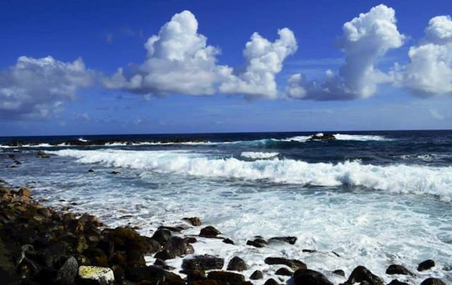
The End of the World
Located in Kona, the End of the World — which you can find by typing in Google Maps; it’s off Ali’i Drive — is where the artery of Ali’i Drive used to end.
After you park your car, hike over lava fields, looking down at crystal waters crashing against long finger-like rock formations jutting out from the shore, crab-speckled volcanic rock and deep caves.
You’ll also find the Lekeleke Burial Grounds, where soldiers rebelling against Christian missionaries in 1820 who wanted to eradicate the local culture are buried.
This is the top hike for adventurous travelers, as it’s a popular spot for cliff diving. While beginners can jump from a 30-foot ledge, true adrenaline junkies should climb to the 40-foot (9-meter) cliff.
Bring your snorkeling gear, as the waters are crystal clear and full of fish.
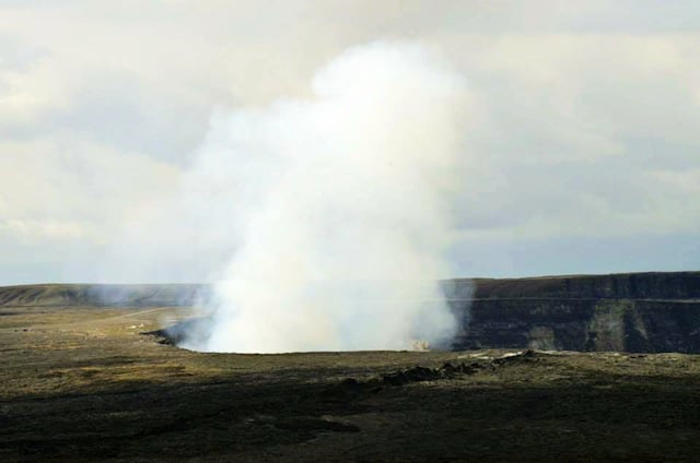
Crater Rim Trail
No Hawaii guide would be complete without mentioning the Crater Rim Trail in Hawaii Volcanoes National Park, on the Hilo side of Big Island. This is a great option for solo travel in Hawaii as it’s within a park with people around.
The entire hike is flat and scenic and is best done with a naturalist guide (they offer this hike free from the visitor center; check the daily schedule) as they can teach you about the flora and fauna along the trail.
The highlight is the viewpoint at the end, as you enjoy unobstructed views of lava fields and the active Kīlauea Caldera and Mauna Loa Volcano. In total, it’s 1 mile (1.6 kilometers) round trip.
Something more challenging — think eight hours and steep ascents — is hiking Mauna Kea, Hawaii’s highest point and the tallest mountain on Earth, with a base-to-summit elevation of 32,000 feet (9,754 meters) and an elevation of 13,796 feet (4,205 meters) above sea level.
Pro tip: This is only for extremely experienced hikers and daredevils as it can be very unsafe. Hawaii Forest & Trail offers the tour that drives you to the summit, although interested parties should book in advance as it tends to sell out quickly.
Keep in mind, Volcanoes National Park isn’t your only park option on Big Island. My recommendation is if you’d like to continue exploring nature, head to Akaka Falls State Park.
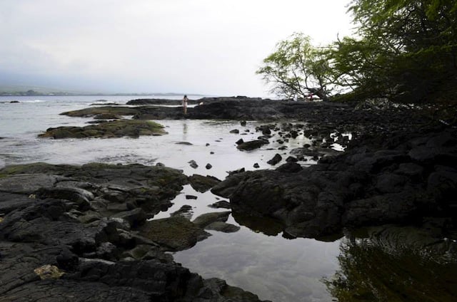
Kealakekua Bay
For your own private Hawaiian beach experience and a mix of landscapes in one journey, the hike down to Kealakekua Bay is challenging but rewarding. It’s a moderate hike, with a semi-steep descent and ascent as well as rocky terrain.
Each way takes about an hour to an hour and a half depending on your fitness level, and I recommend bringing a large water bottle to stay hydrated in the hot Hawaiian sun. From Kuakini Highway you’ll turn onto Napoopoo Road, which will slope downward.
The trailhead is unmarked, but is located near the top of the incline (plus you’ll see many cars parked on the shoulder of the road around the opening).
If you’re using a maps application, type in “Kealakekua Bay Park” to get an idea of where the hike begins.
The scenery starts out with tall grassland and volcanic rock and slowly changes to open lava field to woodland and finally to sea and mountains, with opportunities for bird and butterfly watching throughout.
At the bottom there’s a fork, with both directions leading to enormous rocks where you can sit, picnic and dangle your feet into translucent waters — which are also great for swimming and snorkeling.
The left fork is home to a unique site, the Captain James Cook monument, which marks the spot where he landed in Hawaii (when the locals believed he was god Lono) and was also killed when he returned three months later because a storm set him off course (once the locals realized he wasn’t a god — because what god couldn’t handle a storm? — they weren’t so welcoming).
Overall, it’s a great mix of scenery, history and tranquility. Also, I enjoyed this one while solo hiking and loved it.
My trip to Big Island was sponsored by the Big Island Tourism Board. I was not required to write this post nor was I compensated. All opinions are my own.
Hi, I’m Jessie on a journey!
I'm a conscious solo traveler on a mission to take you beyond the guidebook to inspire you to live your best life through travel. Come join me!
Want to live your best life through travel?
Subscribe for FREE access to my library of fun blogging worksheets and learn how to get paid to travel more!
Turn Your Travel Blog Into A Profitable Business
Subscribe to my email list to snag instant access to my library of workbooks, checklists, tutorials and other resources to help you earn more money -- and have more fun -- blogging. Oh, and it's totally FREE! :) // Privacy Policy.